Contents
Index
Read ESRI Shape File
This option will Read points or strings from an ESRI format shape file.
Two files are used.
The geometry (lines, points) is held in the shape file which has an extension of .shp.
Attributes for each object can be stored in an associated .dbf file and this may or may not be present.
If there is any doubt as to the contents of the dbf file, the tables can be viewed with a spreadsheet program such as Microsoft Excel.
Data in the .shp file can be of type:
- 1 (point)
- 3 (polyline)
- 5 (polygon)
- 11 (pointZ)
- 13 (polylineZ)
- 15 (polygonZ)
Enter the name of the file containing the Shape Data (.shp) to be imported in the top window.
The field below it will show the type of data detected in the shp file.
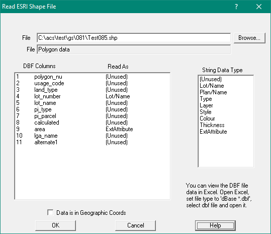
Below that are two windows.
On the left is a list of the data columns held in the .dbf file
On the right is a list of data fields available in Geosurvey Points or Strings.
Point Data
The data items will be "Number", "Name", "Type", "Code", "Remark", "ExtAttribute"
Assign shape columns to Point fields by clicking on each one
String Data
The data items will be: "(Unused)","Name", "Type", "Style", "Colour","Thickness", "ExtAttribute"}
Assign shape columns to Point fields by clicking on each one
Any item which cannot be mapped to a specific data item in Geosurvey can me held as an extra attribute.
Use the mouse to select each dbf column, then use the mouse to select the appropriate string field.
If there is no appropriate parcel data type to correspond with a dbf value, set it to be “unused”.
As a minimum, a column should be set for the Lot/Name and another set for the Plan/Name.
Note: Lot/Name and Plan/Name will both be copied to teh String Name field. The Lot/name will precede Plan/name witha '/' separator.
Thus you might get 12/12345.
Shape data may be stored as geographic coordinates (longitude and latitude)
or as projected coordinates (east and north or X and Y).
If the data is in geographic coordinates tick the check box labelled “Data in Geographic Coordinates”
It is important that an appropriate datum and projection is set for the job as Geocadastre
will transform the geographic coordinates to that datum and projection as they are read in.
Note 1: When reading ESRI Shape Polylines, if the string is closed it will be treated as a Lot instead of a Traverse
Note 2: When reading ESRI Shape Polylines/Polygons, if a plan name is present the plan will be used or created if not present already